- Home Page
- Fact Tours
Our sample tour itineraries of China and China travel packages are sorted by theme and available at competitive prices, you can browse what tours are right for you for your trip to China.
Popular China Tour Packages

Custom Tour Packages to China and Ask Our Experts for Free Enquiry !
- Coach Tours
- Destinations
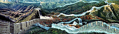
Beijing, the capital of China. Its art treasures and universities have long made it a center of culture and art in China.
Beijing Top Attractions
Beijing City Tours
Best China Tours with Beijing
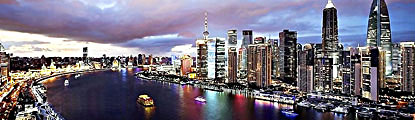
Shanghai, the cultural and economic center of East Asia. It renowned for its historical landmarks, the extensive and growing skyline.
Shanghai Top Attractions
Shanghai City Tours
Best China Tours with Shanghai
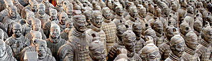
Xi'an, having held the position under several of the most important dynasties. It is the top destination to explore the facts of Chinese history.
Xi'an Top Attractions
Xi'an City Tours
Best China Tours with Xi'an
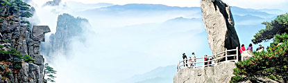
Huangshan boasts its culture, beautiful rivers, villages and mountains. It's home to 2 UNESCO World Heritage Sites and the Mecca of photographers.
Huangshan Top Attractions
Huangshan City Tours
Best China Tours with Huangshan
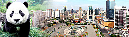
Sichuan is the cradle of the Shu culture, panda, mahjong, teahouse and spicy food. The province ranks first in China by number of UNESCO World Heritage Sites. It is called "the Heaven of Abundance".
Sichuan Top Attractions
Sichuan Tour Packages
Best China Tours with Sichuan
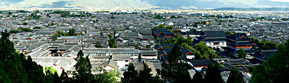
Yunnan, literally means the south of colorful clouds, due to its beautiful landscapes, mild climate and diverse ethnic cultures and traditions, is one of China's major tourist destinations.
Yunnan Top Attractions
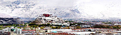
Tibet, the nearest land to the sky, is known for its breathtaking landscape, splendid culture, art, buildings, and mysterious religions.
Tibet Top Attractions
Tibet Tour Packages
Best China Tours with Tibet
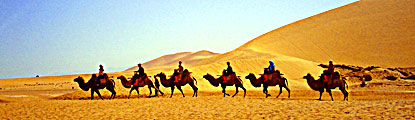
Explore the lost civilizations by riding a camel! Travel across the Gobi and the desert, and over the high mountains. Our Silk Road tours including different sections of the Silk Road in China.
Silk Road Top Attractions
Silk Road Tour Packages
Best China Tours with Silk Road
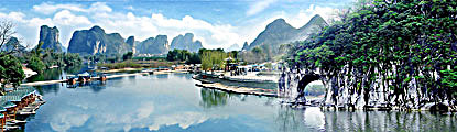
Guilin, an internationally-known historical and cultural city, has long been renowned for its unique karst scenery. Its vicinities are the paradise of hiking, caving, rafting, biking and countryside exploring.
Guilin Top Attractions
- China Facts
- China Hotels
- Travel Photos
Design China Tour!
Not find a wish tour? Select from A La Carte. We do the rest on your interest!
Destinations


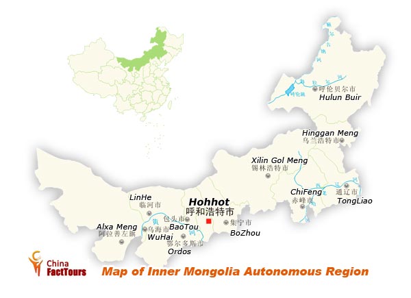
Inner Mongolia
Plateau, with an altitude of more than 1,000 meters, dominate the landscape of Inner Mongolia Autonomous Region. All the plateaus are grossly called the Inner Mongolia Plateau. There are mountains such as Mount Greater Xing’an, Mount Helan, Mount Wula and Mount Dqqing. The Inner Mongolian grassland are of a vast expanse; the two most famous grasslands are the Hulunbuir Grassland and Xinlingol Grassland. Famous lakes refer to Lake Hulun and Buir. The Yellow River – the second longest river in China – flows through the southwestern part of the region. Inner Mongolia belongs to temperate continental and monsoon climate.
The region’s role can be summed up as “the largest ecological protetive screen in the north, the vanguard of opening-up to countries bordering North China and a major resource provider.”
Inner Mongolia has started to speed up its economic development since the dounding of the People’s Republic of China in 1949. Its main industries include mining, metallurgy and rare-earth metal, etc. there are over 60 kinds of minerals, among them rare earth metal, coal and silver are of big reserves. The pastureland in Inner Mongolia is the largest in China. The forestry in Mount Greater Xing’an has a big accumulation of timbers. The region is of China’s important animal husbandry bases, with fertile grasslands. Famous livestock species include Sanhe horse, Sanhe ox and Inner Mongolia fuzz sheep. The local products of fine quality include old-styled purely fur, carpet, goat wool, “facai”- nostoc flagelliforme born et flah, saint gorgeous mushroom, and the Yellow River Carp.
History
Throughout most of history and time, central and western Inner Mongolia, especially the Hetao region, alternated in control between Chinese agriculturalists in the south and Xiongnu, Xianbei, Khitan, Jurchen, Tujue, and Mongol nomads of the north. Eastern Inner Mongolia is properly speaking a part of Manchuria, and its historical narrative consists more of alternations between different groups there rather than the struggle between nomads and Chinese agriculturalists.
During the Zhou Dynasty, central and western Inner Mongolia (the Hetao region and surrounding areas) were inhabited by nomadic peoples such as the Loufan, Linhu, and Dí, while eastern Inner Mongolia was inhabited by the Donghu. During the Warring States Period, King Wuling (340–295 BC) of the state of Zhao based in what is now Hebei and Shanxi provinces pursued an expansionist policy towards the region. After destroying the Dí state of Zhongshan in what is now Hebei province, he defeated the Linhu and Loufan and created the commandery of Yunzhong near modern Hohhot. King Wuling of Zhao also built a long wall stretching through the Hetao region. After Qin Shihuang created the first unified Chinese empire in 221 BC, he sent the general Meng Tian to drive the Xiongnu from the region, and incorporated the old Zhao wall into the Qin Dynasty Great Wall of China. He also maintained two commanderies in the region: Jiuyuan and Yunzhong, and moved 30,000 households there to solidify the region.
After Genghis Khan unified the Mongol tribes in 1206 and founded the Mongol Empire, the Tangut Western Xia empire was ultimately conquered in 1227, and the Jurchen Jin Dynasty fell in 1234. In 1271, Genghis grandson Khubilai established the Yuan Dynasty. Khubilai's summer capital Shangdu (a.k.a Xanadu) was located near present-day Dolonnor. During that time Ongud and Khunggirad peoples dominated the area of Inner Mongolia. After the Yuan Dynasty was evicted by the Han-led Ming Dynasty in 1368, the Ming rebuilt the Great Wall of China at its present location, which roughly follows the southern border of the modern Inner Mongolia Autonomous Region (though it deviates significantly at the Hebei-Inner Mongolia border). The Ming established the Three Guards comprised of the Mongols there. After the Tumu incident in 1450, Mongols flooded south from Northern Mongolia to Southern Mongolia. Thus from then on until 1635, Inner Mongolia was the center of the Northern Yuan Dynasty.
The Manchus gained control of the Inner Mongolian tribes in the early 17th century, then invaded Ming Dynasty in 1644, bringing it under the control of their Qing Dynasty(1644–1912).
Following the end of World War II, the Chinese Communists gained control of Manchuria with some Soviet support, and established the Inner Mongolia Autonomous Region in 1947, following the Soviet model of nationalities policy. Initially the autonomous region included just the Hulunbuir region. Over the next decade, as the communists established the People's Republic of China and consolidated control over mainland China, Inner Mongolia was expanded westwards to include five of the six original leagues (except Josutu League, which remains in Liaoning province), the northern part of the Chahar region, by then a league as well (southern Chahar remains in Hebei province), the Hetao region, and the Alashan and Ejine banners. Eventually, near all areas with sizeable Mongol populations were incorporated into the region, giving present-day Inner Mongolia its elongated shape.
Language
In Inner Mongolia, the official languages are Standard Mandarin and Mongolian, the latter written in the classical alphabet.All street signs must be bilingual with Mongol and Chinese.The Han Chinese of Inner Mongolia speak a variety of dialects, depending on the region. The eastern parts tend to speak Northeastern Mandarin, which belong to the Mandarin group of dialects; those in the central parts, such as the Huang He valley, speak varieties of Jin, another subdivision of Chinese, due to its proximity to other Jin-speaking areas in China such as the Shanxi province. Cities such as Hohhot and Baotou both have their unique brand of Jin Chinese which are sometimes incomprehensible with dialects spoken in northeastern regions such as Hailar.
Mongols in Inner Mongolia speak a variety of dialects of the Mongolian language, including Chahar, Bairin, Ordos, Ejin-Alxa, Barghu-Buryat, etc.; the standard pronunciation of Mongolian in China is based on the Chahar dialect of the Plain Blue Banner, located in central Inner Mongolia. This is different from independent Mongolia, where the standard pronunciation is based on the Khalkha dialect. The Daur, Evenks, and Oroqin speak their own respective languages.
By law, all street signs, commercial outlets, and government documents must be bilingual, displaying both Mongolian and Chinese. There are three Mongolian TV channels in the Inner Mongolia Satellite TV network. A recent trend has also taken place with public transportation, where all announcements are also to be bilingual. Many ethnic Mongols, especially those from the newest generation, speak fluent Chinese, as Mongolian is beginning to recede in everyday use in urban areas. Ethnic Mongols in rural areas, however, have kept their traditions. In terms of written language, Inner Mongolia has retained the classic Mongol written script as opposed to Outer Mongolia's adoption of the Cyrillic alphabet.
Cuisine
The vast grasslands have always been symbolic of Inner Mongolia. Mongolian art often depicts the grassland in an uplifting fashion, emphasizing on the nomadic traditions of the Mongol people. The Mongols of Inner Mongolia practice many traditional forms of art. Inner Mongolian specialty cuisine, largely derived from the tradition of ethnic Mongols, consists of dairy-related products and hand-held lamb. In recent years franchises based on Hot pot had sprung up from Inner Mongolia, the most famous of which is Xiaofeiyang. Inner Mongolia is also known commercially for the brand names Mengniu and Yili, both of which began with the production of dairy products and ice cream.
Tourism
The 880,000-squre-kilometer grassland in Inner Mongolia is fertile and enjoys a splendid view. The Hulunbuir and Xinlingol prairies are the most well known grasslands in the region. Furthermore, countless attraction are scattered amid the primitive forests of the Greater Xing’an Muntains, Badain Jaran Desert and Tengger Desert. Other prime attractions include Genghis Khan’s Mausoleum, Tomb of Wang Zhaojun, Wu Dang Lamasery and Temple of Five Pagodas. Each year there is the traditional “Nadam (meaning entertainment or recreation) Fair in a bid to celebrate a bumper harvest, and the hospital Inner Mongolian people are awaiting visitors from home and abroad and greeting them with fragrant ghee (clarified butter from the butterfat of cow or other milk) tea. The cemetery of the father of the Yunan Dynasty (1279-1368) Genghis Khan (1162-1227), the Sino-Russian market in Manzhouli and the Genentala Prairie all have been appraised as 4A tourist destinations by the National Tourism Administration of China.
-The Five Pagoda Temple in Höhhot, a Buddhist temple.In the capital city Hohhot
-Dazhao Temple is a Lamaist temple built in 1580. Dazhao Temple is known for three sites: a statue of Buddha made from silver, elaborate carvings of dragons, and murals.
-Xiaozhao Temple, also known as Chongfu temple, is a Lamaist temple built in 1697 and favoured by the Qing Dynasty emperor Kangxi.
-Xilituzhao Temple is the largest Lamaist temple in the Höhhot area, and once the center of power of Lamaism in the region.
-Zhaojun Tomb is the tomb of Wang Zhaojun, a Han Dynasty palace lady-in-waiting who became the consort of a Xiongnu ruler.
-Five-pagoda Temple is located in the capital of Inner Mongolia Hohhot. It is also called Jingangzuo Dagoba, used to be one building of the Cideng Temple.[9]
-The Mausoleum of Genghis Khan, the cenotaph of Genghis Khan, is located in Ordos City. Bashang Grasslands, on the border close to Beijing, is a popular retreat for urban residents wanting to get a taste of grasslands life.
-The Arshihaty Stone Forest in Hexigten Global Geopark has magnificent granite rock formations formed from natural erosion.
-Xiangshawan, or "singing sands gorge," is located in the Gobi Desert and contains numerous tourist attractions including sand sledding and camel rides.
Home | About Us | Partnerships | Terms & Conditions | Privacy & Security | Payment Guide | Resource Links| Sitemap
Email: contact@chinafacttours.com, Tel: +86-773-3810160, Fax: (+86) 773-3810333
Copyright © 2008-2020 China Fact Tours. All rights reserved
![]()