- Home Page
- Fact Tours
Our sample tour itineraries of China and China travel packages are sorted by theme and available at competitive prices, you can browse what tours are right for you for your trip to China.
Popular China Tour Packages

Custom Tour Packages to China and Ask Our Experts for Free Enquiry !
- Coach Tours
- Destinations
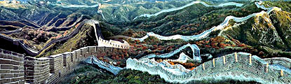
Beijing, the capital of China. Its art treasures and universities have long made it a center of culture and art in China.
Beijing Top Attractions
Beijing City Tours
Best China Tours with Beijing
Shanghai, the cultural and economic center of East Asia. It renowned for its historical landmarks, the extensive and growing skyline.
Shanghai Top Attractions
Shanghai City Tours
Best China Tours with Shanghai
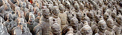
Xi'an, having held the position under several of the most important dynasties. It is the top destination to explore the facts of Chinese history.
Xi'an Top Attractions
Xi'an City Tours
Best China Tours with Xi'an
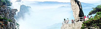
Huangshan boasts its culture, beautiful rivers, villages and mountains. It's home to 2 UNESCO World Heritage Sites and the Mecca of photographers.
Huangshan Top Attractions
Huangshan City Tours
Best China Tours with Huangshan
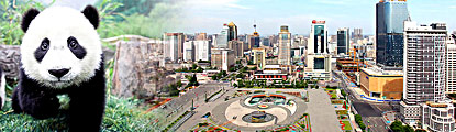
Sichuan is the cradle of the Shu culture, panda, mahjong, teahouse and spicy food. The province ranks first in China by number of UNESCO World Heritage Sites. It is called "the Heaven of Abundance".
Sichuan Top Attractions
Sichuan Tour Packages
Best China Tours with Sichuan
Yunnan, literally means the south of colorful clouds, due to its beautiful landscapes, mild climate and diverse ethnic cultures and traditions, is one of China's major tourist destinations.
Yunnan Top Attractions
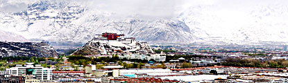
Tibet, the nearest land to the sky, is known for its breathtaking landscape, splendid culture, art, buildings, and mysterious religions.
Tibet Top Attractions
Tibet Tour Packages
Best China Tours with Tibet
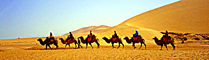
Explore the lost civilizations by riding a camel! Travel across the Gobi and the desert, and over the high mountains. Our Silk Road tours including different sections of the Silk Road in China.
Silk Road Top Attractions
Silk Road Tour Packages
Best China Tours with Silk Road
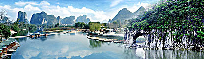
Guilin, an internationally-known historical and cultural city, has long been renowned for its unique karst scenery. Its vicinities are the paradise of hiking, caving, rafting, biking and countryside exploring.
Guilin Top Attractions
- China Facts
- China Hotels
- Travel Photos


Turpan (Turfan)
Turpan, also known as Turfan or Tulufan, is an oasis city in the Xinjiang Uyghur Autonomous Region of China. Its population was 254,900 at the end of 2003.
Geography and Climate
Turpan is located about 150 km southeast of Urumqi, Xinjiang's capital, in a mountain basin, on the northern side of the Turpan Depression, at an elevation of 98 feet (30 meters) above sea level. Turpan's climate is harsh, of the arid continental type, with very hot summers, very cold winters, and minimal precipitation, which amounts to only 20 mm (0.9 inch) per year. July is the hottest month, with average highs of 39°C (103°F) and lows of 25°C (77°F), while January is the coldest, with highs of -4°C (26°F) and lows of -16°C (4°F).[1] The Highest temperature ever measured in Turpan Pendi (155 meters below sea level) is 55.3°C (131.6°F) and the lowest is -38°C (-36.4°F).
However, the very heat and dryness of the summer, when combined with the area's ancient system of irrigation, allows the countryside around Turpan to produce great quantities of high-quality fruit.
History
Tarim Basin in the 3rd centuryTurpan has long been the centre of a fertile oasis (with water provided by karez) and an important trade centre. It was historically located along the Silk Road's northern route, at which time it was adjacent to the kingdoms of Korla and Karashahr to the southwest and the town of Qarakhoja (Gaochang) to the southeast.
The peoples of the Kingdoms of Nearer and Further Jushi (the Turpan Oasis and the region to the north of the mountains near modern Jimasa), were closely related. It was originally one kingdom called Gushi (Wade-Giles: Ku-shih) until it was subdivided after the Chinese conquered it in 107 BCE. During Han era the city changed hands several times between the Xiongnu and the Han interspersed with short periods of independence.
The city again came under control of the Chinese Han Dynasty and, in 60 BC, became part of the Protectorate of the Western Regions. After the fall of the Han Dynasty, the region was virtually independent but tributary to various dynasties. Until the 5th century CE, the capital of this kingdom was Jiaohe (modern Yarghul - 16 km west of Turpan).
Qingnian Lu, a Turpan street shaded by grapevine trellisesFrom 487 to 541 AD Turpan was an independent Kingdom ruled by a Turkish tribe known to the Chinese as the Tiele. The Rouran Khaganate defeated the Tiele and subjugated Turpan, but soon afterwards the Rouran were destroyed by the Gokturks.
In the mid 7th century the Tarim Basin was reoccupied by the Chinese, now under the Tang Dynasty. During the 7th, 8th, and early 9th centuries the whole region was fought over by the Tang, the Empire of Tibet, and the Turks. Under Tang rule, it was a center of major commercial activity between chinese and sogdian merchants. Mazdaism was the religion practiced by the sogdians, and there were many inns in Turpan, some provided sex workers with an opportunity to service the Silk Road merchants since the official histories report that there were markets in women at both Kucha and Khotan. The Sogdian-language contract buried at the Astana graveyard demonstrates that at least one Chinese man bought a Sogdian girl in 639 AD. One of the archeologists who excavated the Astana site, Wu Zhen, contends that, although many households along the Silk Road bought individual slaves, as we can see in the earlier documents from Niya, the Turpan documents point to a massive escalation in the volume of the slave trade.
The few documented pairings of Chinese male owners with Sogdian girls raise the question how often Sogdian and Chinese families intermarried. The historical record is largely silent on this topic, but Rong Xinjiang has found a total of twenty-one recorded marriages in the seventh century in which one partner was Sogdian, and in eighteen cases, the spouse is also Sogdian. The only exceptions are very high-ranking Sogdian officials who married Chinese wives. He concludes that most Sogdian men took Sogdian wives, and we may surmise that the pairings between Chinese men and Sogdian women were usually between a male master and a female slave. Several commercial interactions were recorded In 673 a company commander (duizheng) bought a camel for fourteen bolts of silk from Kang Wupoyan, a non-resident merchant from Samarkand. In 731 a Sogdian merchant sold an eleven-year-old girl to a resident of Chang’an, Tang Rong, for forty bolts of silk. Five men served as guarantors, vouching that she was not a free person who been enslaved (The Tang Code banned the enslavement of commoners.)
The Uyghurs established a Kingdom in Turpan (known as the Uyghuria Idikut state or Kara-Khoja Uyghur Idikut Kingdom) that lasted from 856 to 1389 AD, surviving as a vassal of the Mongol Empire. This Kingdom, led by Idikuts, or Saint Spiritual Rulers, was established after the fall of the Uyghur Empire to the Kyrgyz Turks. Last Idikut left Turpan area in 1284 for Kumul, then Gansu to seek protection of Yuan Dynasty, but local uyghur Buddhist rulers still held power until Invasion of Moghul Hizir Khoja in 1389. Convertion local buddhist population to Islam was completed nevertheless only in the last half of XV century.
Francis Younghusband visited Turpan in 1887 on his overland journey from Beijing to India. He said it consisted of two walled towns, a Chinese one with a population of no more than 5,000 and, about a mile (1.6 km) to the west, a Turk town of "probably" 12,000 to 15,000 inhabitants. The town (presumably the "Turk town") had four gateways, one for each of the cardinal directions, of solid brickwork and massive wooden doors plated with iron and covered by a semicircular bastion. The well-kept walls were of mud and about 35 ft (10.7 m) tall and 20 to 30 feet (6 to 9 m) thick, with loopholes at the top. There was a level space about 15 yards (14 m) wide outside the main walls surrounded by a musketry wall about 8 ft (2.4 m) high, with a ditch around it some 12 ft (3.7 m) deep and 20 ft (6 m) wide). There were drumtowers over the gateways, small square towers at the corners and two small square bastions between the corners and the gateways, "two to each front." Wheat, cotton, poppies, melons and grapes were grown in the surrounding fields.
Turpan grapes impressed other travelers to the region as well. The 19th-century Russian explorer Grigory Grumm-Grzhimaylo, thought the local raisins may be "the best in the world", and noted the buildings of a "perfectly peculiar design" used for drying them.
Questions & Comments
Home | About Us | Partnerships | Terms & Conditions | Privacy & Security | Payment Guide | Resource Links| Sitemap
Email: contact@chinafacttours.com, Tel: +86-773-3810160, Fax: (+86) 773-3810333
Copyright © 2008-2022 China Fact Tours. All rights reserved
![]()