About Us | Contact Us | Feedback
Powered by a China travel agency - Easy Tour China Tel: +86-773-3810160 USA/CA:1-888 666 0951

Design China Tour!

Not find a wish tour? Select from A La Carte. We do the rest on your interest!

Jilin

Jilin shares a borderline spanning more than 1,400 kilometers with the Russian Federation and the Democratic People’s Republic of Korea.

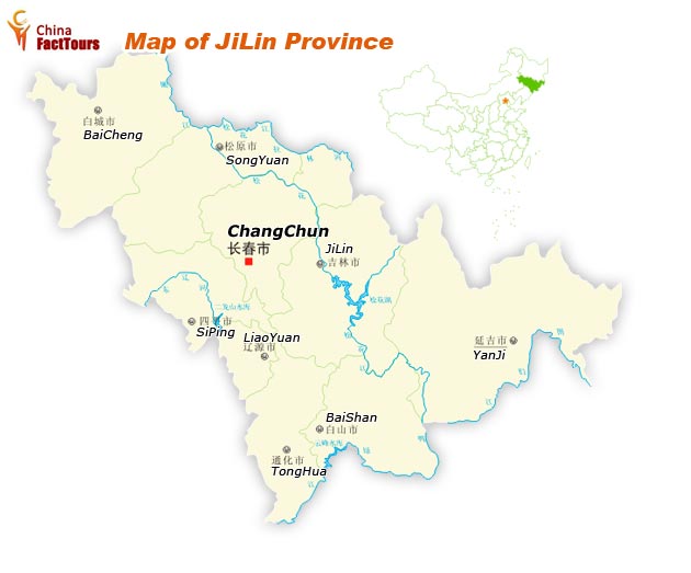
Bordering on Russia in the east and facing the Democratic People’s Republic of Korea, across the rivers of Yalu and Tumen in the southeast, Jilin Province is located in the center of Northeast China, with Liaoning Province to its south, Inner Mongolia on its west and Heilongjiang Province to the north. The name Jilin is the abbreviation of Jilinwula and its transliteration comes from Manchu language.


Map of JilinHistory
In ancient times Jilin was inhabited by various peoples, notably the Mohe and the Wuji. It formed part of the territories of the Han Dynasty and also a part of the Goguryeo kingdom. The kingdom of Balhae was established in the area from 698 to 926 AD. The region then fell successively under the domination of the Khitan Liao Dynasty, the Jurchen Jin Dynasty, and the Mongol Yuan Dynasty. During the Qing Dynasty, much of the area was under the control of the General of Jilin, whose area of control extended to the Sea of Japan to encompass much of what is Russia's Primorsky Krai today. Immigration of Han Chinese was strictly controlled.

However, after the Primorsky Krai area was ceded to Russia in 1860, the Qing government began to open the area up to Han Chinese migrants, most of whom came from Shandong. By the beginning of the twentieth century, Han Chinese had become the dominant ethnic group of the region. In 1932, the area was incorporated into Manchukuo, a puppet state set up by Japan, and Changchun (then called Hsinking), capital of Jilin today, was made the capital of Manchukuo. After the defeat of Japan in 1945, the region, together with the rest of northeastern China, was handed to the communists by the Soviet Union. Manchuria was then the staging ground from which the communists eventually conquered the rest of China (see Chinese Civil War Post-war power struggle (1945–1947)).

In 1949, Jilin province was smaller, encompassing only the environs of Changchun and Jilin City, and the capital was at Jilin City, while Changchun was a municipality independent from the province. In the 1950s Jilin was expanded to its present borders. During the Cultural Revolution, Jilin was expanded again to include a part of Inner Mongolia, giving it a border with the independent state of Mongolia, though this was later reversed. In recent times Jilin has, together with the rest of heavy industry-based Northeast China, been facing economic difficulties with privatization. This has prompted the central government to undertake a campaign called 'Revitalize the Northeast'.

Geography and Climate
Jilin lies in the central part of northeastern China, bordering Russia and North Korea in the east and southeast respectively. Jilin has a total area of 190,000 square kilometers and a total population of 27.3 million. Its capital is Changchun, which lies 113 kilometers west of Jilin city. Jilin province is rich in natural mineral deposits with 136 different types of minerals, of which 70 have already been extracted. Jilin has abundance of Traditional Chinese medicine resources, with approximately 27,000 kinds of wild plants and 9,000 kinds of medicinal herbs. Also the province is rich in large reserves of oil, gas, coal, iron mine, nickel, molybdenum, talc, graphite, gypsum, cement rock, gold and silver; its reserves of oil shale are the largest in the country.

Jilin is highest in altitude in the southeast, and drops gently towards the northwest. The Changbai Mountains run through its southeastern regions, and contains the highest peak of the province, Baiyun Peak at 2691 m. Other mountain ranges include the Jilinhada Mountains, Zhang Guangcai Mountains, and Longgang Mountains.

Jilin is drained by the Yalu and Tumen Rivers in the extreme southwest (which together form the border between the People's Republic of China and North Korea), by tributaries of the Liao River along the southern border, and by the Songhua and Nen rivers, both eventually flowing into the Amur. Jilin has a northerly continental monsoon climate, with long, cold winters and short, warm summers. Average January temperatures range from -20 to -14°C. Rainfall averages at 350 to 1000 mm.

Culture
Jilin is part of Northeast China, so shares many similarities in culture to neighbouring regions, such as Er Ren Zhuan, Stilts and Yangge. But among its music, Jiju, or Jilin Opera, is a form of traditional entertainment that Jilin has innovated over its short migrant history. The ethnic Koreans of Jilin have their own distinct culture. See also: Yanbian Korean Autonomous Prefecture, Culture of Korea.

Tourism
The Goguryeo sites and tombs found in Ji'an, Jilin, including Wandu, Gungnae Fortress, and the pyramidal General's Tomb, have been listed as part of a UNESCO World Heritage Site. The Baekdu Mountain, especially Heaven Lake on the border with North Korea, are popular tourist destinations due to their natural scenery. Ancient Tombs at Longtou Mountain, including the Mausoleum of Princess Zhenxiao, are royal tombs of the Balhae kingdom found in Yanbian Korean Autonomous Prefecture.